Využití geofyzikálních metod při mapování pozůstatků raně středověké hutní činnosti ve střední části Moravského krasu
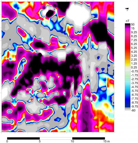
Cílem příspěvku je seznámení s možností využití geofyzikálních metod pro detekci zaniklých hutních pracovišť. Čtenáře seznámíme se základním principem magnetometrie a metody magnetického mapování. Z výsledků vyplývá, že v poměrně krátké době lze nedestruktivním způsobem nejen detekovat i hluboko uložené zbytky po hutní výrobě a tím lépe odhadnout význam i rozsah lokalit, ale také lze dobře zmapovat rozsah zaniklých milířišť, jejichž plošiny se v dnešní krajině ztrácí.
Use of geophysical methods in mappin g the remains of early medieval metallur gical activities in the central part of the Moravian Karst
The aim of the paper is to present the possibility of using geophysical methods for detecting the extinct metallurgical sites. The reader will be introduced to the basic principles of magnetometry and magnetic mapping methods. The results show that in a relatively short period of time, not only can the deeply buried remains of metallurgical production be detected in a non-destructive way and thus the significance of the sites can be better estimated, but also the extent of extinct charcoal burning sites, whose platforms are being lost in today‘s landscape, can be well mapped.